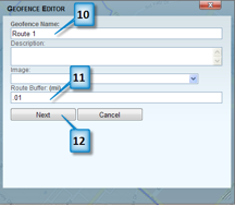
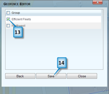
A route geofence is used to make sure that a vehicle stays on a fixed path. For example, you may have a delivery vehicle that you want to follow a designated route. A route geofence can verify that the vehicle stayed on course. All route geofences have a buffer that allows the vehicle to leave the path. This could be used for example to allow a vehicle to exit the highway to get gas. You define the buffer when you save the route.
1. Click on the Geofence tab.
2. Click on Create Geofence.
3. Click on Route.
4. Enter an address including city, state, and zip where you want to begin the route.
5. Click Locate. You should now see an icon on the map indicating where the address is located.
6. Click on the map to start drawing the route.
7. Continue clicking on the map to define the route.
8. Click on the Save button once you are done.

9. Click on the Geofence tab.
10. Click on Create Geofence.
11. Click on Route.
12. Enter an address including city, state, and zip where you want to begin the route.

13. Click Locate. You should now see an icon on the map indicating where the address is located.
14. Click on the map to start drawing the route.

15. Continue clicking on the map to define the route.
16. Click on the Save button once you are done.


